

Growing with
Green
Infrastructure
by
Karen S. Williamson, RLA, CPSI
Landscape Architect
Heritage Conservancy
Preserving our Natural and
Historic Heritage
www.heritageconservancy.org


Study with the several resources on Docsity

Earn points by helping other students or get them with a premium plan

Prepare for your exams
Study with the several resources on Docsity
Earn points to download
Earn points by helping other students or get them with a premium plan
The history of infrastructure development in the us and its impact on the environment. It introduces the concept of sustainable development and green infrastructure as a solution to preserve natural systems and enhance quality of life. A case study of hope township and their implementation of green infrastructure principles.
Typology: Study notes
1 / 20

This page cannot be seen from the preview
Don't miss anything!
Preserving our Natural and Historic Heritage www.heritageconservancy.org
Copyright© 2003 by Heritage Conservancy. All rights reserved.
The Industrial Revolution created new spheres of influence and unprecedented concentrations of wealth. Fortunately, leaders in a variety of fields not only invested in the technological advances that enabled society to evolve, but also had the foresight to use their public stature and/or the financial proceeds from their success to support philanthropic efforts to address the social consequences of such advancement. Influential figures included Teddy Roosevelt, who guided the construction of the Panama Canal and fostered the development of our National Park System, and Andrew Carnegie, a leader in the steel industry that built many of our infrastructure systems and a patron of higher education and scientific research programs.
As the 20th Century unfolded, the adverse effects of many infrastructure systems on the environment became apparent. In her groundbreaking book, Silent Spring , Rachel Carson spotlighted the dangers of chemicals in our world, prompting the reversal of some previously accepted practices and stimulating the development of innovative solutions to other environmental impacts. The banning of the pesticide DDT, the enactment of auto emission control standards and the establishment of recycling programs reflected an increasing awareness of the stresses being placed on the environment by society. This awareness was matched by a growing interest and participation in land and water conservation efforts to protect important natural resources.
At the same time, the public was discovering that environmental issues were crossing geopolitical boundaries, not only at the local and state level but nationally and internationally. Acid rain was a problem for both the United States and Canada, since industrial pollutants carried by prevailing winds did not recognize national borders, and the burning of South American rain forests had implications for global warming. The rapid pace at which an exploding world population was consuming land and natural resources inevitably raised the question of a finite limit to the environment’s capacity to support human life.
Sustainability and Green Infrastructure
In 1983, the United Nations’ World Commission on Environment and Development brought together representatives of 21 countries, including the United States, to discuss sustainable development – how to promote economic development throughout the world without adversely impacting the environment and depleting natural resources needed by future generations. The Commission stressed that sustainable development could “only be pursued if population size and growth are in harmony with the changing productive potential of the ecosystem ” – the ecosystem being the collection of living organisms and the physical environment upon which they depend for survival.
However, the development of land for agricultural, residential, commercial, industrial and institutional uses and the associated man-made infrastructure needed to support these uses has reduced, fragmented and degraded nature’s ecosystems.
In Who Sprawls Most? How Growth Patterns Differ Across the U.S. , the Brookings Institution reported on dramatic levels of urban sprawl across the United States. The study reported a nationwide rise in land development of 47% compared to an increase in the U.S. population of only 17% in a 15-year period (1982 -1997). These imbalances are evident in the Philadelphia Region, as documented by the Delaware Valley Regional Planning Commission in its publication, Horizons: The Year 2050 Plan for the Delaware Valley – Report #3: The Preliminary Land Use Plan, A Vision of Renewal for the 21st Century. A comparison of population and land use statistics from 1930 to 1990 reveals that the amount of developed land has increased five times faster than the total population over this 60-year period. From 1970 to 1990 alone, land was consumed at a rate of nearly an acre every hour every day for 20 years.
The impact of such growth has decreased nature’s ability to respond to both short-term changes, such as flooding and drought, and long-term environmental trends, such as the spread of invasive species and global warming. Because changes in land use happen gradually, the increasing fragmentation of natural systems may not be immediately obvious.
Man and nature, both in constant motion, are often at odds. The infrastructure improvements that facilitate the movement of people, goods and information have created an ever-growing network of barriers to our natural systems. In conflict with the natural landscape, these barriers foster a patchwork distribution of land uses and isolate open space areas.
The competing elements of this man-made infrastructure have also impeded natural processes that involve the migration of animals, the flow and filtration of water and the parachuting of seeds and spores upon the wind. The social consequences of this spatial fragmentation include a decline in the productivity of the environment to support human activities and the alienation of man from nature.
Fortunately, there is an alternative that can provide a better balance.
A sustainability pyramid illustrates how a viable ecosystem serves as the foundation for our society by providing the natural resources we need to support our human systems and man-made surroundings. A variety of natural processes interact to create a healthy environment, allowing us to harvest the food we eat and obtain the raw materials to build our communities. (See Figure 1).
Biodiversity is the web of life. The sustainability concept recognizes the need for mankind to tap into natural systems in order to improve the quality of life, but it encourages us to do so in a manner that enhances, not destroys, the natural processes we rely on for our very existence.
“How long
can we go on
and safely
pretend that
the
environment
is not the
economy, is
not health, is
not the
prerequisite to
development,
is not
recreation?”
What constitutes Green Infrastructure?
Green infrastructure consists of several components that work together to maintain a network of natural processes. These components range in size and shape depending upon the type and the scale of the resource being protected. The rarity or ecological importance of the natural features within each component determines the level of conservation required to protect these resources, while the sensitivity of the environment to human activity determines how much interaction between man and nature is appropriate.
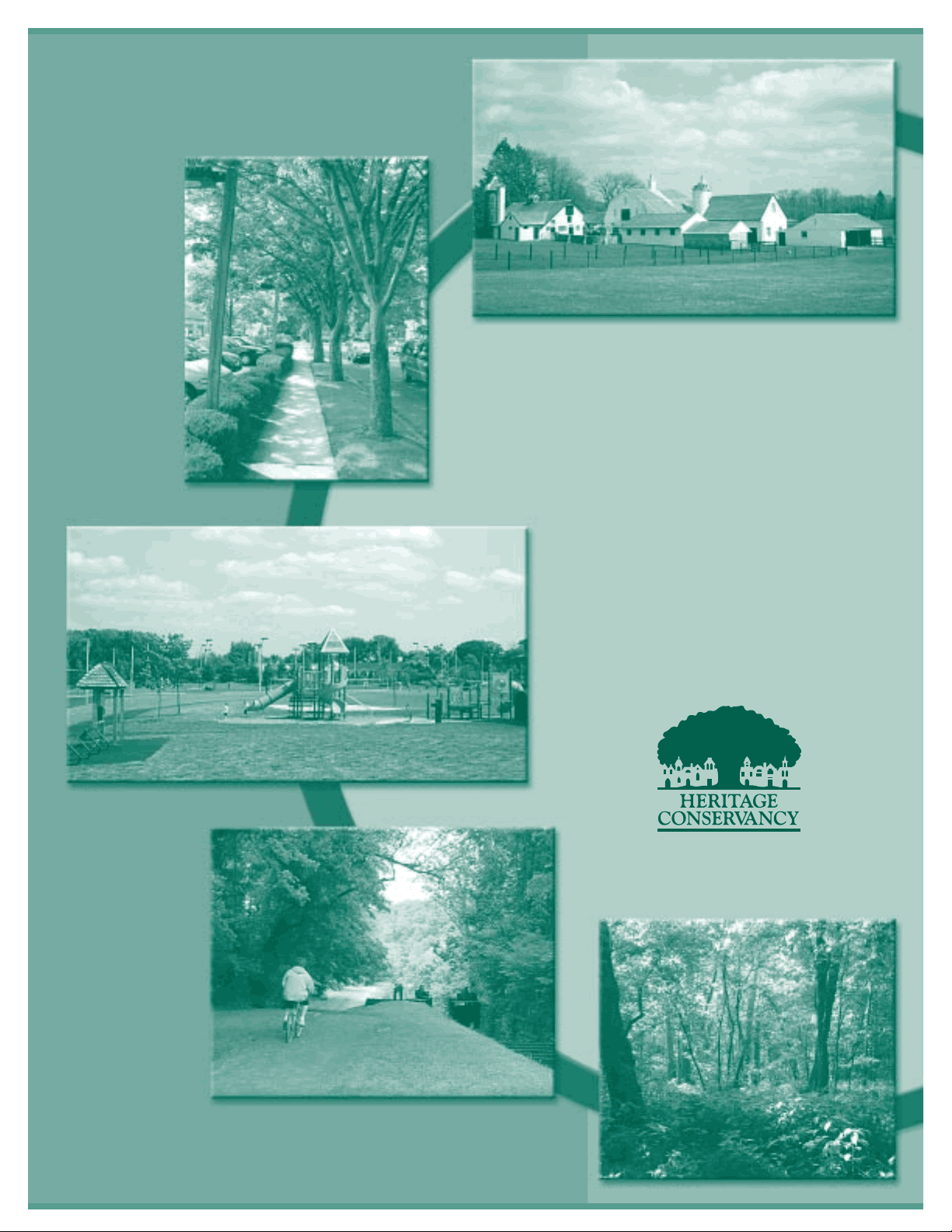
Hubs: Act as an “anchor” for a variety of natural processes and provide an origin or destination for wildlife. Hubs include:
Reserves: Lands that protect significant ecological sites, including wildlife areas typically in their pristine state, such as the John Heinz National Wildlife Refuge.
Managed Native Landscapes: Large publicly owned lands, such as the Allegheny National Forest, managed for resource extraction as well as natural and recreational values.
Working Lands: Private working lands, including farmland, forests, and ranch lands.
Parks and Open Space Areas: Landscapes at the national, state, regional, county, municipal and private level that may protect natural resources and/or provide recreational opportunities. Examples include public parks, natural areas, playgrounds, and golf courses.
Recycled Lands: Lands that were previously damaged by intense public or private use and that have since been restored or reclaimed. Mined lands, landfills or brownfields that have been improved in total or in part to provide an environmental function are examples of recycled lands.
Links: Interconnect the hubs, facilitating the flow of ecological processes. Links include:
Conservation Corridors: Linear areas, such as river and stream corridors that serve primarily as biological conduits for wildlife and may provide recreational opportunities. Greenways and riparian buffer areas are examples of conservation corridors.
Greenbelts: Protected natural lands or working landscapes that serve as a framework for development while also preserving native ecosystems and/or farms or ranchlands. They often act as partitions within a community – a form of visual and physical relief in the landscape – separating adjacent land uses and buffering the impacts of these uses. Farmland preservation areas can be considered greenbelts.
Landscape Linkages: Open spaces that connect wildlife reserves, parks, managed and working lands and provide sufficient space for native plants and animals to flourish. In addition to protecting the local ecology, these linkages may contain cultural elements, such as historic resources, provide recreational opportunities and preserve scenic views that enhance the quality of life in a community or region. Landscape linkages may include streetscapes and recreational trail corridors.
Pennsylvania’s
once-boundless
forests are
now divided
into more than
377,
fragments,
91% of which
are smaller
than 25 acres.
More than
half of the
forests lie
within 100
yards of fields,
roads or some
other non-
wooded cover.
Less Human Interaction
More Human Interaction
Less Human Interaction
More Human Interaction
“When we
examine
anything in
the universe
we find that it
is hitched to
everything
else.”
The interconnection of hubs and links is critical in providing both landscape connectivity for ecological functions and for passage and dispersal of wildlife. (See Figure 2).
Creating a Green Infrastructure System
The procedure for establishing a green infrastructure system starts with a thorough understanding of two important aspects of a community:
- The ecological forces at work in the area. An analysis of the specific types, extents and qualities of the vegetation, wildlife, topography and resources of an area should be made to determine the role that each landscape feature plays in supporting natural processes. An assessment of their current condition will reveal which aspects of the landscape are at risk and how damage to these resources might adversely impact the sustainability of the region. To the greatest extent possible, scientific principles should be used to perform this analysis to substantiate the findings and conclusions. - The social fabric of the community and its relationship to the surrounding region. Demographic information, historical research and economic data should be used to identify development patterns and trends and determine how these factors have shaped the community. An organized public participation process should encourage a range of individuals to work together to develop a vision for the future development of the community.
With this knowledge, the goals and objectives of the green infrastructure system can be determined and prioritized. These objectives should highlight:
HUB
HUB
HUB LINK
LIN K
LIN K
LIN
K
LIN (^) K
LINK
LINK
Figure 2– Conceptual Green Infrastructure System
Pennsylvania’s
landscape is
separated into
seven major
categories –
forests,
grasslands and
open areas,
barrens,
subterranean
(caves),
wetlands,
aquatic (tidal
areas, lakes
and streams)
and disturbed.
development would worsen flooding, threaten water supplies, alter the farming community, and destroy the scenic views of the nearby hillside.
The audience at the planning commission meeting was anxious to hear how a new plan would help address existing concerns and accommodate future changes in the community. Different strategies were needed to resolve existing problems and manage change within various areas of the township.
The planning commission created a study committee with the sole purpose of recommending a new plan for Hope Township based upon the green infrastructure concept. The composition of the committee reflected the wide range of community interests, including some planning commission members in addition to the county extension agent and the community development director. A biologist, community planner, landscape architect, township engineer and the township solicitor were retained to provide technical expertise throughout the planning process.
The county extension agent and community development director explained how the concept of green infrastructure could be used as the framework for preparing a long-term land use plan for Hope Township. In essence, the committee would work with the consultants to identify the unique natural processes and cultural features in the township, and then use existing land use tools to protect and maintain these elements as part of a green infrastructure system that would enhance the quality of life. The decision-making process would be based upon an understanding of ecology and a desire to strike a balance between protecting natural resources and supporting community development.
Everyone understood that change was inevitable and that preventing further development of any kind was not only unrealistic, but also undesirable. However, the participants in the planning process would have to learn more about the scientific principles that were at work in the environment in order to make wise choices about the future growth of their community.
The study committee recruited students from the planning department at the nearby community college to prepare Geographic Information System maps showing a variety of existing features in the township and its surrounding region, such as topography, geology, soils, water resources, vegetation, zoning districts, land uses, wildlife habitat, public parks and farmlands. The drawings enabled the committee to visualize these features during meetings and facilitate discussion.
The biologist explained how plants and animals coexist in various combinations in the environment based upon the physical characteristics of the landscape. The amount of space that different
plants and animals need to live and breed varies with the species, depending upon migration and settlement patterns. Some species are “generalists” and adapt to a range of landscape conditions while others are “specialists”, requiring a habitat composed of very specific elements. Large patches of vegetation in the landscape support more wildlife than smaller ones, and certain plants and animals make their home in the interior of the patch while other species prefer the edge. Wildlife movement occurs when favorable habitat areas are physically connected or are in close proximity.
There were three basic landscape types in Hope Township – the forested hills, cultivated farmlands, and disturbed village. (See Figure 3). Each landscape type not only created different habitats for wildlife but also different resources for man’s use. For example, hillsides supported woodlands harvested for timber and critical habitat for rare wildlife. Lowland areas lacking a drainage outlet contain wetlands that not only provide a habitat for wildlife but also filter and absorb rainfall, keeping ground water supplies clean. Cultivated lands provided a source of food and acted as a transition between the village environment and the forested hillside.
Even though some committee members had lived in the township for years, many of them were pleasantly surprised by what they learned from the inventory. So far, the green infrastructure planning process had been a valuable educational experience.
ROUTE 10
CR E EK
CO
RR
ID
OR
CR EE K CO (^) R RI D RO
STRE AMC ORRIDOR
CREEK CO RR ID OR
RAIL ROAD
SPUR
M AI N TS .
WETLANDS
STREA^ M
COR^ R I^ D^ O^ R
HOMES
PUBLIC WELL
PAINT FACTORY
BRIDGE
STORE
Figure 3 – Landscape Types – Hope Township
Disturbed Village Landscape:
Wetland Hub: There was a large wetland on the abandoned paint factory property. The redevelopment of this brownfield site presented an opportunity for restoration of the wetland and integration of this open space into the village community.
Park and School Hubs: The junior high school and two elementary schools provided public spaces in the township for residents to socialize and enjoy the outdoors. Three small community parks were also identified as important green spaces accessible to residents.
With the green infrastructure hubs identified, the committee next considered how best to link the hubs to provide connections for ecological processes as well as for interaction between the residents and the nearby natural areas.
AQ
UA
TI CL
IN K
PRIME AGRICULTURAL SOILS HUB
PRIME AGRICULTURAL SOILS HUB
RAILL INEL I N K
AQ UA T I C LIN K
AQUA TIC LI NK
CLEAN WATER HUB
BROWNFIELD
ENDANGERED SPECIES HUB
ENDANGERED SPECIES HUB
STATE GAME LANDS HUB
A QUAT ICLI NK
A^ QUATIC LINK
ROUTE 10
CR
E EK
CO
RR
ID
OR
CR EE K CO R R ID O R
STR EAM CORRID OR
CREE K CO RR ID OR
RAIL
ROAD
SPUR
M A IN ST .
WETLANDS HUB
STREA^ M
CORR I^ D^ O^ R
HOMES
PUBLIC WELL
PAINT FACTORY
BRIDGE
STORE
SCHOOL
PARK
Figure 4 – Hubs and Links – Hope Township
Rail Line Link: Raw materials and finished products were once transported to and from the paint factory via a railroad spur that went through the village and included a bridge across the stream. The spur connected to the abandoned railroad right-of-way that had recently been purchase by the county for future use as a recreational trail. The committee agreed that converting the spur to a rail-trail should be considered, in light of the potential for this route to link the township with natural and recreational areas elsewhere in the region.
Aquatic Link: The creeks and the stream could be used to link a number of green infrastructure components, since these watercourses crossed through each of the landscapes and provided links to several of the hubs.
Pedestrian Link: Linking parks and schools to each other and to the natural areas of the community would expand access and provide healthy recreation for residents.
The hubs and links were added to the collection of drawings prepared by the community college students for the study committee. With each layer of information, a pattern in the distribution of natural and cultural resources began to take shape. The committee could now see how the railroad spur and watercourses could connect the different hubs and landscape types within the community and link the township’s green infrastructure system to other municipalities in the county.
The study committee divided its members into four smaller groups, with each responsible for recommending the specific steps needed to achieve one of the principles for building the green infrastructure system. Each group presented a preliminary list of recommendations for critique and coordination. The committee refined these ideas into a coherent action plan and map of the green infrastructure system.
The results were compiled into a draft report that included a proposed timetable, cost estimate and funding options for completing the recommendations. The study committee and the commission jointly presented the final report at a public meeting before the Hope Township’s Board of Supervisors, who adopted the green infrastructure plan and agreed to budget funds each year for implementing the plan’s recommendations. (See Figure 5).
The township then formed an environmental advisory council, as permitted by law, from the study committee’s members, to work with the board of supervisors on implementing the recommendations in the action plan. Over the next five years, Hope Township was able to achieve a number of its goals using a variety of land planning techniques and working with a wide range of partners:
Green Infrastructure Investments and Accomplishments:
“Our
metropolitan
areas are
crisscrossed
with
connective
strips. Many
are no longer
used,... but
they are there
if only we will
look.”
Conclusion
The example of Hope Township reinforces several important principles that, when implemented properly, contribute to a successful green infrastructure plan:
Use a comprehensive approach to planning. The goal of a green infrastructure system is to establish a framework for coordinating conservation efforts. Keep an open mind about what should be included in this system.
Plan ahead. It easier and more cost effective to protect the environment before land development happens than to restore natural processes after they are impaired.
Learn as much as you can. There is often no single source for information about the natural ecology of your area and the latest land planning techniques. Get the professional expertise you need to make sure the green infrastructure plan is based upon accepted scientific knowledge and sound land use practices. (See also References).
Encourage public participation. Identify potential partners and finds ways to include a variety of stakeholders in the planning and implementation process.
Promote biodiversity. Create variation in the landscape by protecting natural resources that differ in size and type and then find a way to link these resources. Think beyond municipal boundaries to connect with landscape features in the surrounding region.
Incorporate the human element. Green infrastructure is not intended to isolate people from nature by creating a separate network of open spaces just for wildlife. Its purpose is to weave nature back into the community in a way that facilitates various levels of human interaction with the environment based upon the resiliency of the natural resources being protected.
Make the tough choice. Building a green infrastructure system is an investment in your future. Promote the hidden value of green infrastructure and commit the time and money to bring the plan to fruition.
As civilization progresses, so does our understanding of the environment and our appreciation of its contribution to the quality of life. Great strides have been made to protect precious natural resources. Take the next step in the conservation process by using green infrastructure to care for the natural processes that sustain us.
Green Infrastructure...Let natural systems work for you...
Acknowledgements
Heritage Conservancy is a non-profit organization dedicated to preserving our natural and historic heritage. This publication was made possible in part through a legislative initiative grant from Representative Charles T. McIlhinney, Jr., and financed by the Commonwealth of Pennsylvania, Department of Community and Economic Development.
Copyright© Heritage Conservancy
85 Old Dublin Pike, Doylestown, PA 18901 (215) 345-7020 • Fax (215) 345- www.heritageconservancy.org email: [email protected]
v1/082003/