


Ahmed Sami 140845
Ahmed Al Sayed 140259
Abdelftah Mohamed 130036
Mostafa Yassen 141006


Study with the several resources on Docsity

Earn points by helping other students or get them with a premium plan

Prepare for your exams
Study with the several resources on Docsity
Earn points to download
Earn points by helping other students or get them with a premium plan
Dar zarrouk parameters
Typology: Slides
1 / 44

This page cannot be seen from the preview
Don't miss anything!
- Ahmed Sami Data were interpreted using partial curve matching technique and assisted 1-D Forward modeling with WINRESIST software. The qualitative interpretation revealed KQ curves (ρ1 < ρ2 > ρ3 >
. ρ4) and KH curve (ρ1 < ρ2 > ρ3 < ρ4)
The geoelectric section generated from the results of the VES revealed a four geo-electric layers; these include topsoil with resistivity ranging from 213-5404 Ωm, dry sand with resistivity values vary from 301to 17178 Ωm, saturated sand with resistivity varying from 110 to1724 Ωm and sand (saline water content) with resistivity values of between 8 and 97 Ωm. The major aquifer in the area occurs at the third geoelectric layer The depth to this aquifer is of between 0.7m and 6.0m and the layer thickness is between 0.2 m and 19.9 m
It has high transverse resistance, high transmissivity, and high hydraulic conductivity indicating that the aquifer can transmit water at higher rate and sustain the need of the community
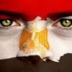
INTRODUCTION. 1 Groundwater as one of the main sources of potable water supply for domestic, industrial and agricultural uses has been under intense pressure of degradation an contamination due to urbanization, Industrial, agricultural
. related activities and saline water intrusion from the ocean The impact of these contaminations on soil and groundwater is alarming with years of devastating effects on humans and the ecosystem
Despite the fact that Lagos coastal environment is surrounded by water, access to potable water has always being their major problem due to saline water intrusion into their fresh water aquifer, which is very common in areas that have hydraulic continuity with the ocean. Due to this problem, the Lagos coastal people depend mainly
. on surface aquifer to meet their water demand Therefore, understanding of saline water intrusion is essential for the management of coastal water resources. The knowledge of the hydraulic characteristics of an aquifer is very important in the determination of its potential as potable water aquifer
LOCATION OF THE STUDY AREA The study area (Lekki free zone) is located between Latitude 6°25’ and 6°27’ north of the equator and Longitude 3°57’ and 4°03’ (Fig. 1). It is found within the sedimentary basin (Dahomey basin) of southern The landmass of the study area consists of islands, coastal sand banks, high forest (i.e mangrove or swamp and rain forest). western Nigeria.
GEOLOGY OF THE AREA
Agenda Dar-Zarrouk Parameters The story of this presentation SLIDE 19 Let it begin! Used Array Used Array Dar-Zarrouk Parameters Dar-Zarrouk Parameters END END Transverse Resistance Transverse Resistance Protective Capacity Protective Capacity Longitudinal Conductance Longitudinal Conductance HYDRAULIC CONDUCTIVITY HYDRAULIC CONDUCTIVITY Transmissivity of the Aquifer Transmissivity of the Aquifer Porosity and Formation factor Porosity and Formation factor Relation Relation
Using the Schlumberger electrode array Used Array We are very glad to meet you. SLIDE 20 What we are talking about today. (^) Twenty-one VES points were occupied by the side of the major road that runs through the study area (^) The investigation was carried out with the aid of Pasi Digital Earth Resistivity Meter. (^) The current electrode is symmetrically increased (^) potential electrode is fixed at its initial distance (^) AB/2 ≥ 5(MN/2) was satisfied. (^) AB/2 was increased to a maximum spread of 100 m (^) MN/2 to a maximum of 5m (^) The apparent resistivity (Pa) is plotted against the corresponding half electrode spacing(AB/2) on a bi-logarithm graph to generate the sounding curves. Pasi Digital Earth Resistivity meter